
Walking Purchase Park, also known as Lehigh Mountain Park, or "Sals" among the biking community, is a little section of undeveloped land along the south bank of the Lehigh River between Bethlehem and Allentown. It's comprised of several tracts of land, and is spread across several jurisdictions but is managed by Salisbury Township.
In the early 2000's, the Valley Mountain Bikers approached the township with a proposal to build and maintain a trail system on Lehigh Mountain. The bulk of the trails were designed and built over the next few years, and by 2008 the current trail system was complete. It is now considered the "Jewel of Mountain Biking" in the Lehigh Valley, especially by the locals who built and ride it.
| Back to Top | Back to LV MTB Page |
Getting There: There are a number of entrances to the Sals trail system, but if you're showing up by car the best place to start is at the Dodson Street trailhead, which is located in a town park and ballfield, at the end of Dodson Street in Fountain Hill.
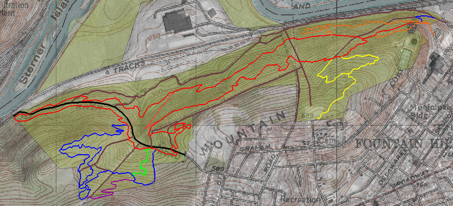
The Trail System: Trails at Sals are color-coded, and follow a "stacked loop" design: the trail system is made up of three main loops (blazed yellow, red and blue), with several connectors and side trails (orange, purple and green) shooting off from the main loops. (See the map below.) A typical ride at Sals would follow the main loops around the park's perimenter, with a few side trails thrown in, for a grand total of about 10 miles. The surface is rocky and the total elevation gain for a typical loop is about 1300 feet, a reasonably strong rider should be able to complete the loop in just under two hours.

The best path to take if starting from Dodson is to follow the perimeter counterclockwise: yellow trail, to red, to orange, back to to red, then blue, purple, blue, red, and finally yellow back to Dodson. The trails are well marked, but if you have a smartphone, this map can be useful on the trail, or if you use GPS contact me for GPX tracks of this route.
| Back to Top | Back to LV MTB Page |
Mountain biking is inherently risky, and the trails at Walking Purchase Park are rugged and difficult. If you decide to ride there, you assume the risks of riding Sals. (In other words, if things go wrong there, it's your fault and your problem, not mine or anyone else's.)
The Township of Salisbury has a waiver to this effect, and requires all riders to fill out and sign one. You can obtain a copy of the waiver from the Valley Mountain Bikers trail page for Sals, along with an official, printable map, and a host of other information about riding (including night riding) at the park.
| Back to Top | Back to LV MTB Page |